Since June, scientists have been warning that Earth might experience an El Niño unlike any other. It now appears they were right. The periodic climate beast that emerged this year is stronger than any ever seen. And the really worrisome news: It likely hasn’t even reached its peak.
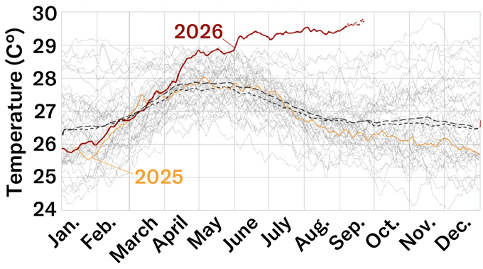
El Niños develop in the central and eastern equatorial Pacific Ocean. Over a short period, they release extraordinary amounts of ocean heat into the air. And by September 21, the daily sea-surface temperature where El Niños form was already 3.08 degrees Celsius (5.54 degrees Fahrenheit) warmer than the average from 1991 to 2020.
El Niños can fuel droughts, floods, heat waves and severe storms. The Oceanic Niño Index is a traditional measurement of their strength. Using daily sea-surface temperatures to calculate strength shows that the 2026 event is already more intense than any in recorded history.
“It has been a remarkable event,” says Nathaniel Johnson. What’s more, the climate scientist notes, this El Niño will probably strengthen even more. He expects it to peak “within the next few months.” Johnson works at the Geophysical Fluid Dynamics Laboratory in Princeton, N.J. It’s part of the National Oceanic and Atmospheric Administration (NOAA).
Ocean heat released by this El Niño could spike global land temperatures about 1.2 degrees C (2.16 degrees F) in the coming months. That may not sound like much. But by next February, it could lead to more than 450,000 additional heat-related deaths. That’s the finding of a new report out of the University of Chicago’s Climate Impact Lab.
NOAA has not yet formally called this El Niño a record-breaker. Why? It’s using a new measurement method: the Relative Oceanic Niño index. That should better capture how an El Niño’s heat will alter weather across the globe. And by this index, the El Niño in 1997 and 1998 topped the new one’s current strength.
But that record, too, is on track to be broken soon, based on a Sept. 10 forecast by NOAA’s Climate Prediction Center.
To understand what’s driving this historic event and its potential impacts, Science News spoke with two experts. One is Johnson, part of that U.S. team that produces El Niño forecasts. The other, Nathan Lenssen, is a climate scientist at the National Center of Atmospheric Research. It’s in Boulder, Colo. Their answers have been edited for length and clarity.
How much of this El Niño’s strength has been fueled by human-caused climate change?
Johnson: It’s really an unanswered question. If we look at the historical record, we have been seeing more rapid swings between El Niño and La Niña. [La Niña is the other — and opposite — extreme phase of a seesawing pair of climate patterns: Together they’re known as ENSO, or the El Niño Southern Oscillation.] There’s some evidence from computer models that increasing greenhouse-gas emissions lead to more of those extreme [ENSO] swings. But there’s no science consensus yet on how climate change is impacting El Niño. Especially an extreme one, like this.
Lenssen: There’s debate on how much we can directly attribute to climate change. But due to Earth’s warming, there is more energy in the oceans now. And El Niños release some of that ocean heat into the atmosphere.
What are the most predictable and unpredictable impacts of this El Niño?
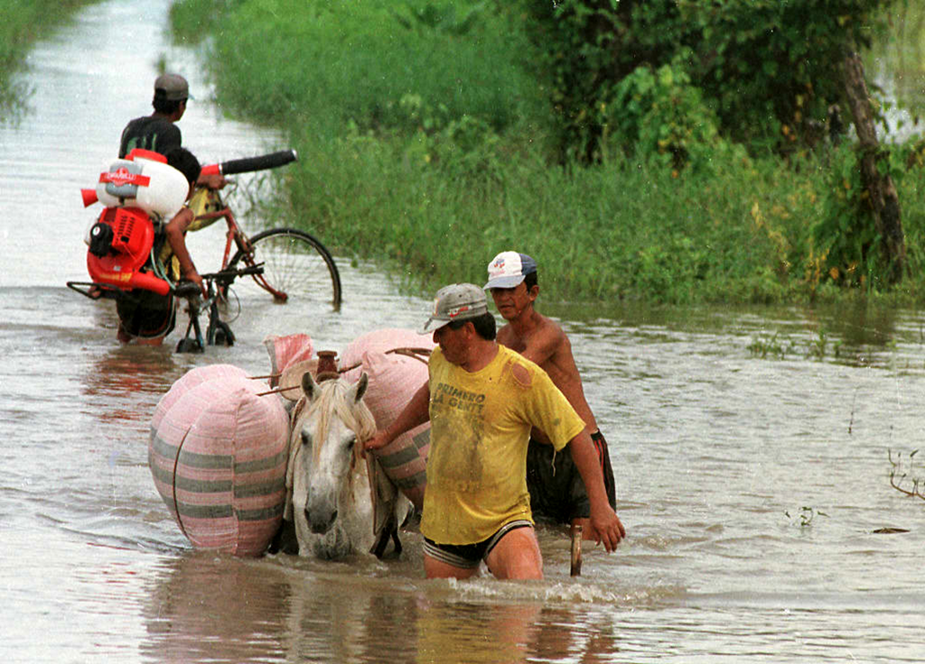
Johnson: We see a lot of the most predictable impacts in the tropics. That’s where an El Niño develops. We’ve already seen a suppressed Atlantic hurricane season and enhanced Pacific hurricane season. We’ve also seen droughts in Central America. We tend to see droughts over northern South America and the Amazon. Meanwhile, the Indian monsoon can weaken.
By late fall, we typically see more impacts a bit farther from the equator. For instance, we tend to see more rain over the southern United States, but it’s typically drier than normal over the Pacific Northwest. And it’ll be warmer than average over the northern United States and Canada.
Lenssen: While this El Niño is quite powerful, that doesn’t necessarily mean we’re more confident about its impacts. A global warming of the oceans has made some historical changes seen at mid-latitudes less likely.
So there’s a kind of twist there. The El Niño in 2023 and 2024, for instance, didn’t lead to as much wet weather in California as expected. And some research has shown that was due to other warming ocean patterns.
How long could this El Niño last?
Johnson: El Niños typically last a year. So we’ll probably see this one weaken after winter and be over by spring or early summer. But when we have a big El Niño like this, we’re more likely to see a shift in the following year to La Niña [which also has global impacts on weather]. So that’s something we’ll be keeping our eye on.
Lenssen: It’s possible that this event could be followed by a double La Niña. Those occur back-to-back, separated by a brief period of neutral conditions. That happened in 2016 and 2017, after the strong El Niño of 2014 and 2015.
Do you have a science question? We can help!
Submit your question here, and we might answer it an upcoming issue of Science News Explores
Aside from strength, what sets this event apart from past ones?
Johnson: We’ve seen such a dramatic change in the equatorial Pacific Ocean. The move has been very rapid, from a La Niña last winter to a very strong El Niño — all in less than a year. That might be the fastest transition that we’ve seen.
Is there any sort of silver lining here?
Lenssen: Though more work is needed to understand this, some research suggests future El Niños may actually become more predictable as the world continues to warm. That might give us months of additional lead time to prepare for their impacts. And that would be great.
In hot water
Since El Niño emerged in June, the daily average sea-surface temperature has become extraordinarily high in the heart of the Pacific Ocean region where El Niños develop. On September 21, it reached 3.08 degrees Celsius (5.54 degrees Fahrenheit) above both the 1991 to 2020 average (coarse dashed line) and the 1982 to 2010 average (fine dashed line). Prior to September 2026, the most extreme anomaly on record was 3.02 degrees Celsius, set by an El Niño in November 2015.